|
Have you been flying in areas where you don't have maps for? Have you ever tried to plan a flight for X-Plane without maps?
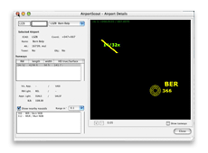
PATHy currently deals with 13025 airports, 3204 VORs, 6684 NDBs, 1930 ILS and 15948 fix points from the apt.dat, nav.dat and fix.dat files from X-Plane 4
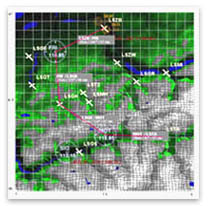
PATHy displays the airports and navaids on a scalable map, and you can simply select the various leg points and create a nice flight plan with heading, distance and estimated leg time.
You can print the map and the flight plan, and you can easily use underlying maps to have more information for your VFR flight planning.
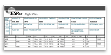
PATHy calculates distance, bearing, trip time at given speed, fuel consumption, overall trip cost, flight profile climb & descent rates etc.
|
|
PATHy 2.1 includes a couple of new user requested features, and it is OS X ready! Beware that PATHy 2 was built for OS X 10.2 and it has not been tested or updated to deal with MacOSX 10.4 and above. It might run, but it is not supported.
Download the latest fix to make it run on 10.4.
See the tutorial pages for more detailed view of the features
PATHy was built from scratch to fit the daily activity of the worlds most (in)famous pilots: the crew of dESPair airline (www.despair.ch).
The crew of dESPair is not flying from Paris to London in a fat tin can all day. They are providing all sorts of support and emergency services in virtually any spot of this world. And what they need for these kind of tasks is a handy tool to plan VFR flights, SAR patterns, SOAS missions.
PATHy is not a toy for the airliner business where you fly from way point to waypoint. PATHy is your guide dog for flights at 100 ft AGL in mountaneous scenery.
|